 HackerTube.runGood videos, with context.
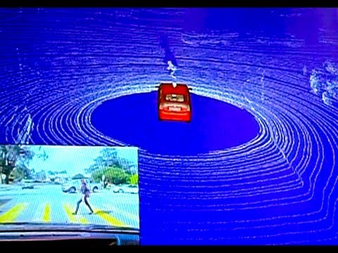
How Google's Self-Driving Car Works
About this video
Part 2 of the IROS 2011 keynote by Sebastian Thrun and Chris Urmson on Google's self-driving car. It shows how the car perceives its surroundings with a lidar point cloud and recognizes traffic lights and pedestrians. The audio is poor because it was recorded on a pocket camcorder.
Why it appears in the archive
HN recommends it as a technical talk aimed at a real engineering audience, with live demos of perception and pre-mapped roads.
AI-generated summary and labels from the source dataset; verify important details against the video. Source & credits.
From the Hacker News discussion
[VIDEO] 9:00 has a good example, recognizing the state of a traffic light, other cars and pedestrians at an intersection, but lots of cool videos starting around 3:40. The whole talk is awesome and a presentation for an actual technical audience, too.
Read original comment ↗There's a great presentation about Google's self-driving car here (check the second half for video of the real-time telemetry that it gathers): [VIDEO] One of the things that I found really interesting is how the car inches forward at a stop sign in order to show the "driver's" intent to other drivers. Lots of actions that seem to be second-nature for human drivers have to be carefully emulated here.
Read original comment ↗The picture Gross shared is a frame from a 1.5 year old promo[1], so he may also have misheard 1Gb for 1GB. [1] [LINK] – the bottom image is from this presentation: [VIDEO]
Read original comment ↗What about "Haha, Well you're certainly not going to create a 3D point cloud of every street in the world"... Google's self driving cars are just doing that. EDIT: I can't find the post I once read, but this post also makes some clear: [LINK] EDIT 2: Here a video of the presentation: [VIDEO] @ 3:30 you can see the generated (and stored) point cloud.
Read original comment ↗That's a load of FUD. Modern Self driving cars track people on sidewalks not just the street. As to driving in the rain, they can do it, but like poeple there less safe at highway speeds in the rain. [VIDEO] (6:45, 9:00) Also, 3:52 demos stopping for someone in the road. They even read stop lights (8:00). PS: If you actually look at that left turn on @9:00 the car has a much better idea what's around it than people do.
Read original comment ↗Isn't Google's approach dependent on expensive LIDARs and high resolution 3D maps [0], or have they changed that? I don't see that kind of system scale well. [0] [VIDEO]
Read original comment ↗If I'm not mistaken, this is the presentation that discusses mapping the roads before autonomous travel. They compare the maps to what the car sees as it drives. [VIDEO] But there are a number of reasons the need pre-mapping are not a huge issue. A) When autonomous cars start to be introduced people will still know how to drive, and can pilot the car through unmapped areas. By the time everyone has an autonomous car, and no one knows how to drive the world will be mapped. B) Google has already shown with Streetview that they can create detailed, up-to-date maps of most roads. C) This problem will likely be solved in time.
Read original comment ↗