 HackerTube.runGood videos, with context.
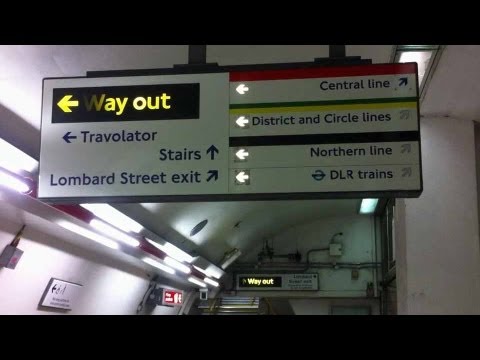
Lies on the London Underground
About this video
Tom Scott and Matt Parker investigate some of the small deceptions and oddities of the London Underground, such as misleading signage and map distortions.
Why it appears in the archive
Cited as an example of quirks caused by non-geographic maps and design choices in transit systems.
AI-generated summary and labels from the source dataset; verify important details against the video. Source & credits.
From the Hacker News discussion
Metro maps are optimized for finding your way from one metro station to another. But what I really want is to go from one physical location to another, and that is made more difficult because those distorted metro maps don't map very well to the physical layout of the area. It's often difficult to see how the metro stations correspond to physical locations, and therefore not straightforward to find out the best total route (i.e. including walking from starting point to metro station, metro, walk from metro to destination, possibly other transportation options). Edit: Tom Scott has a video (somewhat theatrically titled "Lies on the London Underground") that highlights some peculiarities of the London Underground, some of which are (partly) caused by the non-geographic nature of the maps: [VIDEO]
Read original comment ↗Could this be simply a case of "the needs of the many outweigh the needs of a few"?. For example I live near a busy road during "rush hour" in the morning and evenings. A few mins up the road from me 2 major roads intersect which causes more hassle during these peak times. Now If you are travelling West to East to wish to turn right at the intersection to continue your journey south its quicker during those times to cut though my neighborhood (and same in the other direction) and cut out the queues leading up to the intersection. However my neighborhood's roads are not designed for that much traffic to flow though them (cars parked in the street narrowing the roads and reducing visablity of pedestrians esp kids playing outside). The handful of locals that travel though the neighborhood to get home (live one side but enter the other) are fine however if Google Maps routed everyone wishing to make that turn though the neighborhood it would make the neighborhoods roads much less friendly to the pedestrians of the neighborhood esp at times kids are going to school or are back home from school and playing outside. Keeping the through traffic to the major roads keeps everyone safer, and actually faster overall because the major roads aren't littered with cards parked in the road creating bottlenecks. Much like how the london underground lies to travellers and routes them around long detours during busy periods to help prevent a crush if they all went the shortest & fastest route po
Read original comment ↗That's how global optimisation works. Generally speaking you will always miss out on a bunch of local optima when you go for a global optimum. This was well understood by designers in metro systems like the London Underground[0] and road signs. When each individual strives for the best result for themselves (a local optimum) we often end up in a worse result for everyone (see tragedy of the commons, prisoners' dilemma etc). [0] [VIDEO]
Read original comment ↗